

Hitech Innovation co, as a specialized professional mapping and land surveying company, offers a comprehensive range of services in the field of Topographic Survey, Land Survey, and GIS Mapping.
- Hitech Innovation co. conducts topographic surveys, which involve mapping the natural and man-made features of a specific area. These surveys provide essential information for land development, infrastructure planning, and environmental assessments.
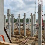
- Services include Civil Construction Survey, High Rise Building Survey, Mechanical Survey, Plant Construction Survey, Pipeline Survey, Railroad Survey, and Earthwork Quantity Survey.
- The Survey Crew at Hitech Innovation co. ensures accurate data collection, which is crucial for various projects.
- Geographic Information System (GIS) mapping involves creating digital maps that integrate spatial data with attribute data. Safe Automations excels in this field.
- Services encompass Road Profile Designing using the latest CAD tools. They specialize in Earthwork Construction, Highway and Road Construction, and various civil infrastructure projects within the Kingdom of Saudi Arabia.
3D Modeling and Laser Scanning:
- Hitech Innovation co. leverages cutting-edge technology for capturing as-built conditions with precision.
- 3D laser scanning rapidly captures existing structures, terrain, and objects. Once assembled, these scanned images reveal intricate building relationships that are often challenging to visualize.
- Architects, design professionals, engineers, and builders benefit from the detailed spatial information provided by Hitech Innovation co.
In summary, Hitech Innovation co. plays a crucial role in shaping the built environment by combining expertise in surveying, GIS mapping, and advanced 3D modeling techniques. Their commitment to accuracy and innovation ensures successful project outcomes
